Scenario 3

Scenario 3: Northern Expansion

What if… Saltash grows to the north?

Key Features

  • Saltash grows by 33% to 19,000 population with approx. 1,800 homes at Treledan, at previously developed and waterfront sites within the town and extensions to Pill and Carkeel and major employment land east of Carkeel (Hole Farm)
  • Includes a new primary school at Pill, a new health centre at Treledan, and highways/active travel/bus service improvements at Glanville Terrace/North Road to serve Pill

Key Effects

  • Improves access to school places and healthcare
  • Significant dependency on improving active travel and bus service infrastructure to connect new housing to the town
  • Significant new employment land
  • Adverse landscape effects
  • Growth distributed at three distinct locations limits infrastructure improvements

What could it look like?
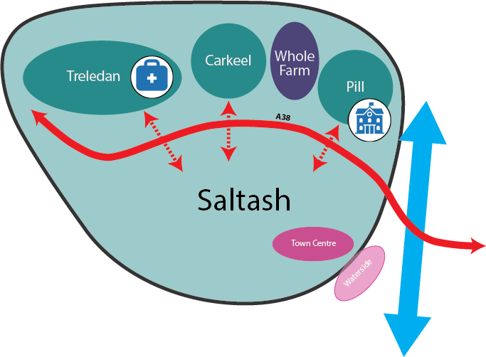
Diagram of Scenario 3 for Saltash. The outlined Saltash boundary extends north of the A38, which runs west to east through the town and crosses the River Tamar to the east. North of the road, inside the boundary, are four areas from west to east. Treledan is a housing area with a health centre. Carkeel is a housing area. Whole Farm is an employment area. Pill is a housing area with a primary school. Treledan, Carkeel and Pill are each linked by travel connections across the A38 to central Saltash. The Town Centre and the Waterside are in the south-east by the river. Latchbrook and St Stephens do not appear.
Diagram of Scenario 2 for Saltash. Saltash is a smaller outlined oval that sits entirely south of the A38. The A38 runs along its northern edge and crosses the River Tamar to the east. Treledan is a separate housing area to the north-west, beyond the A38 and outside the town boundary. It contains a local centre, a health centre and a primary school. A single wide travel connection crosses the A38 to link Treledan to Saltash. Inside the town, Latchbrook in the west is linked to the centre. The Town Centre and the Waterside are in the south-east by the river. Carkeel, Pill and St Stephens do not appear.
